£435.00 ex VAT
Delivery: approx 3 days.
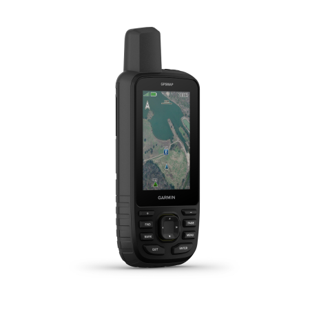
Garmin GPSMAP H1 is the latest premium GPS on the market for challenging locations. As such, exploration geologists and surveyors who will find themselves in during mineral exploration projects and surveys. The unit is rugged, waterproof, shock proof and features a colour touch scree as well as physical buttons. Boasts 64 GB of memory, which you can expand with a micro SD card up to 1 TB. As well as smart features and the ability to download additional apps or connect to other devices and smart phones. It’s built in lithium ion batter will last you 145 hours in GPS mode, which you can extend to over 800 hours in expedition mode. Keep you mineral exploration and geological survey mapping data safe and accurate with the new Garmin GPSMAP H1.
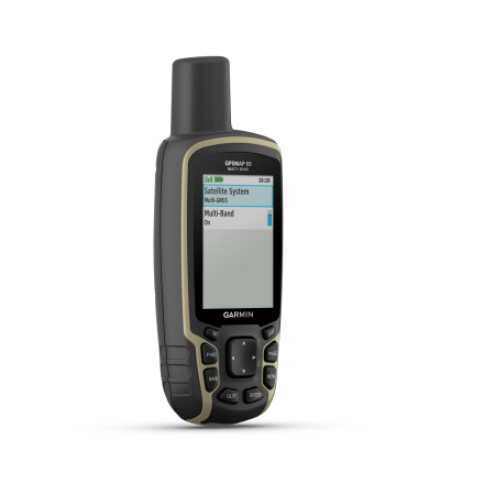
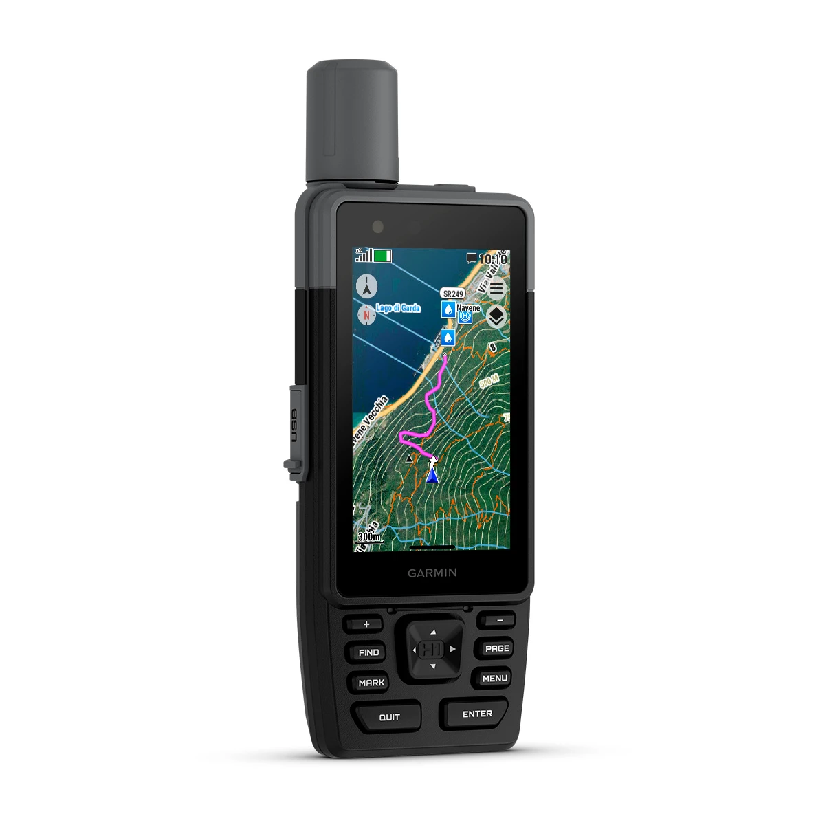
Garmin GPSMAP H1 is the latest premium GPS on the market for challenging locations. As such, exploration geologists and surveyors who will find themselves in during mineral exploration projects and surveys. A rugged, waterproof model which now boasts both physical button and a colour touch screen with a high-sensitivity receiver. The unit offers a range of beneficial features for those working outdoors.
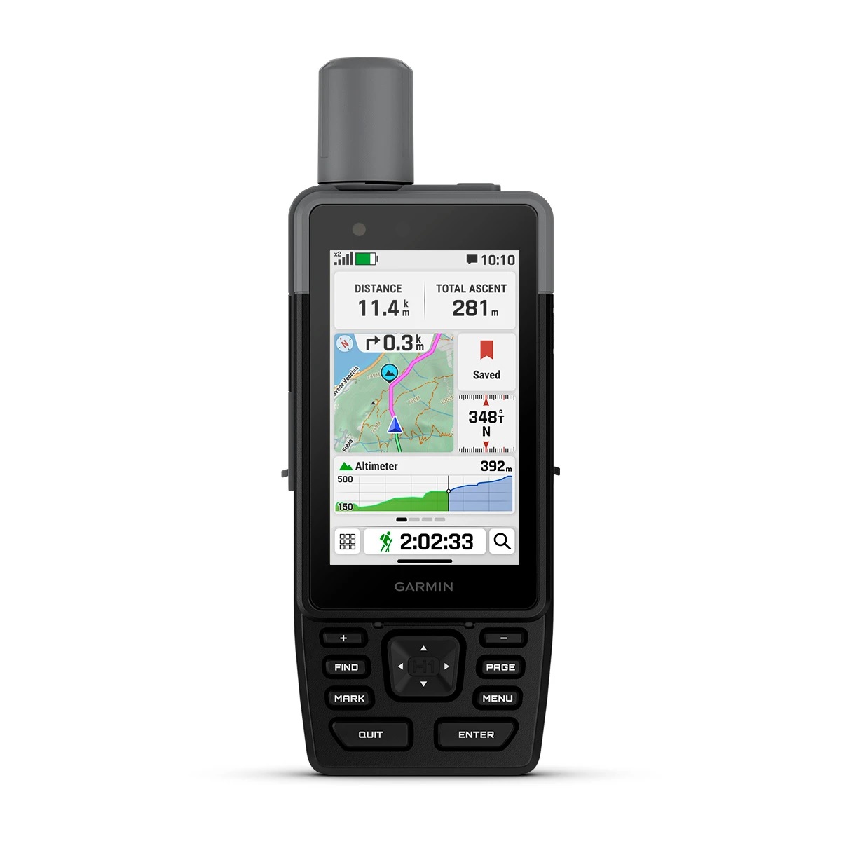
The GPSMAP H1, out of the box features a generous 3.5-inch color screen with transflective properties. Allowing you to view the screen with ease, even in the sun without any glare. The internal lithium battery will last you 145 hours in the standard GPS mode, however in expedition mode you can expect up to 840 hours of use. A must-have on sites lacking power for recharging the battery.
Additionally, the unit provides a generous 64 GB of memory storage as standard, but you can expand this with a microSD™ card (up to 1 TB max). With this addition, you can store more data, including routes, waypoints, tracks, locations, maps and map updates, geocaches, and so on.
As well as the above, the GPSMAP H1 also comes as standard with multi-band technology. It will lock onto a number of satellite networks to give you the fastest and most accurate readings and grid references. (GPS, GLONASS, Galileo, QZSS, and IRNSS). This can mean all the difference for those sampling in more unexplored terrain, miles from the nearest community, or even roads.
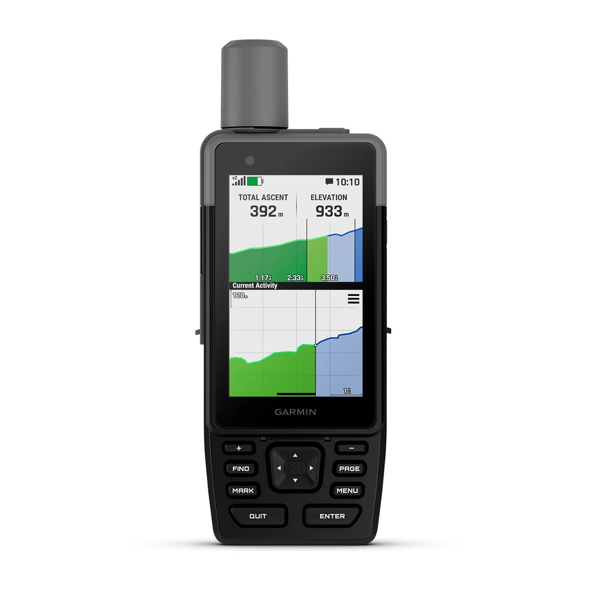
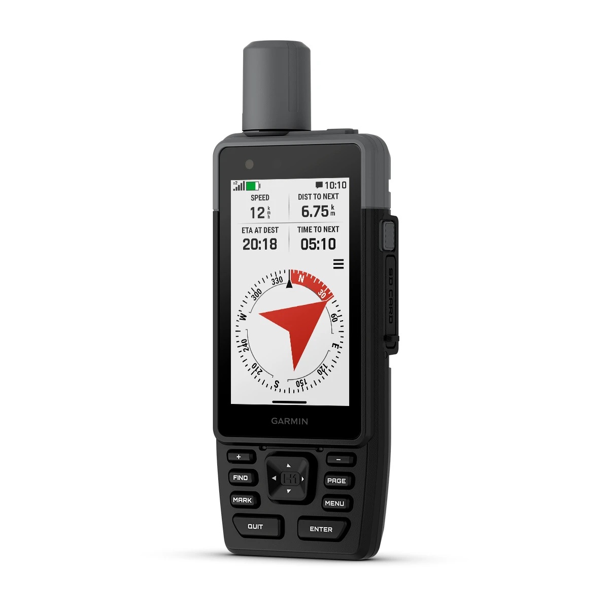
As expected from a premium model, the unit also comes with a barometric altimeter enables you to determine your height and current air pressure conditions. As well as a 3-axis tilt-compensated compass that provides bearings and on-the-go directional navigation.
The new H1 premium GPS also has numerous smart features, via Garmins Connect IQ, which allow for additional apps and downloads on the device. Such as watch faces and data fields. Users can also turn on smart notifications, weather monitoring and connect to other Garmin devices or your own smart phone. As well as featuring a touch screen keyboard for ease and importantly, a pass code function. Protecting your data should the unit be lost.
The unit packs all of the above features and more into a comfortable-to-use hand-held navigation unit. Measuring only 6.7 x 17.9 x 3.3 cm in size and a total weight of 276 grams. It is no burden to carry but provides host of benefits to your outdoor activities, mapping, and mineral exploration projects that cannot be ignored.
Including 3.5 inch colour touch screen with 282 x 470 pixels. With a transflective TFT coating which can be viewed even in the glare of the sun. Long-life rechargeable lithium ion battery offering between 145 to over 800 hours of use (depending on settings). The GPS is also IP67 water rating, with the bare unit also being thermal and shock proof.
The Garmin GPSMAP H1 is an extremely versatile, accurate, and tough navigation unit. An excellent receiver with connection to multiple satellite networks, colour screen hard casing, generous data storage, and connectivity to other devices makes it the perfect ‘all-rounder’ of GPSs.
For this reason, it has seen use in a range of areas outside of just hiking, tracking, and the outdoors. But also on mineral exploration projects, drilling sites, geological mapping as well as other earth science areas. Such as ecology, geography, anthropology, and more.
The data it can provide is crucial to your project and having trust in such a device is important. Garmin carries with it a recognizable brand name that is trusted the world over and it will not fail you.
| General | |
|---|---|
| Lens material | Chemically strengthened glass |
| Dimension | 6.7 cm x 17.9 cm x 3.3 cm (2.6″ x 7″ x 1.3″) |
| Weight | 276 g (9.7 oz) |
| Water rating | IP67 |
| MIL-STD-810 | Yes (thermal, shock, water); bare unit only |
| Touchscreen | Yes |
| Display Type | Transflective colour TFT |
| Display Size | 4.7 x 7.7 cm (1.9″W x 3″H), 8.9 cm (3.5″ diagonal) |
| Display Resolution | 282 x 470 pixels |
| Battery type | Rechargeable, internal lithium-ion |
| Battery life | All Satellite Systems + Multi-Band: Up to 145 hours* Expedition Mode: up to 840 hours *Assuming typical use with SatIQ™ technology |
| Memory/history | 64 GB (user space varies based on included mapping) |
| Interface | USB-C |
| Maps & memory | |
|---|---|
| Preloaded maps | Yes |
| Ability to add maps | Yes |
| Basemap | Yes |
| Automatic routing (turn by turn routing on roads) for outdoor activities | Yes |
| Map segments | Yes (15,000) |
| Satellite Imagery | Yes (direct to device) |
| Includes detailed hydrographic features (coastlines, lake/river shorelines, wetlands and perennial and seasonal streams) | Yes |
| Includes searchable points of interests (parks, campgrounds, scenic lookouts and picnic sites) | Yes |
| Displays national, state and local parks, forests, and wilderness areas | Yes |
| Storage and Power Capacity | Yes (1 TB max microSD card) |
| Waypoints | yes |
| Courses | Unlimited |
| Activities | unlimited |
| Activity profiles | Yes |
| GPX imports | Yes |
| Rinex logging | Yes |
| Sensors | |
|---|---|
| GPS | Yes |
| Galileo | Yes |
| QZSS | Yes |
| BeiDou | Yes |
| IRNSS | Yes |
| Barometric altimeter | Yes |
| Compass | Yes (tilt-compensated 3-axis) |
| High-sensitivity receiver | Yes |
| GPS compass (while moving) | Yes |
| Multi-band frequency | Yes |
| Daily smart features | |
|---|---|
| Connect IQ™ (downloadable watch faces, data fields and apps) | Yes |
| Smart notifications on handheld | Yes |
| Weather (removing Active) | Yes |
| Compatible with Garmin Connect™ Mobile | Yes |
| Garmin Share | Yes |
| Passcode | Yes |
| Auto correct keyboard | Yes |
| Safety and tracking features | |
|---|---|
| LiveTrack | Yes |
| Safety siren | Yes |
| Tactical features | |
|---|---|
| Compatible with AB Synapse | Yes |
| Ballistics solver | Yes (unlock required) |
| Dual grid coordinates | Yes |
| Night vision mode | Yes |
| Outdoor recreation | |
|---|---|
| Point-to-point navigation | Yes |
| Spoken turn-by-turn directions | Yes |
| TracBack® | Yes |
| Area calculation | Yes |
| Sun and moon information | Yes |
| Geocaching-friendly | Yes (Geocache Live) |
| Custom maps compatible | Yes (500 custom map tiles) |
| Picture viewer | Yes |
| inReach remote widget | Yes |
| LED beacon flashlight | Yes |
| Flashlight | Yes |
| inReach® features | |
|---|---|
| inReach remote compatible | Yes |
| Outdoor applications | |
|---|---|
| Compatible with Garmin Explore™ app | Yes |
| Garmin Explore website compatible | Yes |
| Dog tracking | Yes (when paired to compatible dog track system) |
| Connections | |
|---|---|
| Connections Wireless Connectivity | Yes (Wi-Fi®, BLUETOOTH®, ANT+®) |
| Security Information | |
|---|---|
| Security updates until at least (YYYY-MM-DD) | 2027-09-03 |